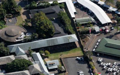
Refurbishing existing buildings rarely starts with reliable information. In South Africa, original as-built drawings are often missing, outdated, or disconnected from what actually exists on site. Alterations accumulate over decades, undocumented and unverified, until the drawings no longer resemble reality.
At that point, every refurbishment decision is made on partial knowledge and guesswork .
Terrestrial laser scanning combined with 3D Revit models offers a faster, more accurate way to establish an understandable as-built baseline 3D model before design begins. It replaces assumption with measured reality and gives project teams confidence in common information sources underpinning their design process and confirming that what they design can actually be built.
The problem with missing or outdated as-built drawings
When accurate as-built information is unavailable, refurbishment projects slow down and risk multiplies:
- Existing conditions are unclear or misinterpreted
- Services and structure clash unexpectedly on site
- Manual surveys take days and still miss detail
- Design revisions cascade into rework and cost overruns
- Access constraints increase safety and programme risk
These issues are not design failures. They are information failures.
How terrestrial laser scanning creates accurate as-built data
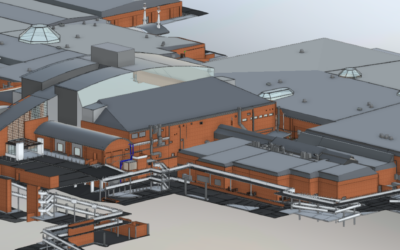
Terrestrial laser scanning captures millions of measured points that describe the true geometry of a building. Walls, slabs, beams, columns, plant, and MEP services are recorded exactly as they exist, not as they were once drawn and originally built or modified.
For refurbishment projects, this means:
- Accurate spatial data captured rapidly, often in a single site visit
- Minimal disruption to occupied or operational buildings
- Complete coverage of complex or congested areas
The result is a reliable 3D digital record of existing conditions that can be used with confidence by the project team.
Why 3D Revit models reduce refurbishment risk
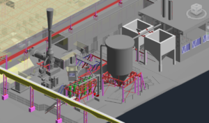
When laser scan data is converted into a structured 3D Revit model using Autodesk workflows, the point cloud becomes an intelligent, usable design asset.
A Revit model derived from laser scanning allows teams to:
- Identify clashes and constraints early in the design process
- Test refurbishment options against real geometry
- Coordinate architecture, structure, and services in a single environment
- Reduce late-stage design changes and construction rework
This both decreases risk and raises risk flags earlier where it is cheaper and easier to manage.
Time and cost savings compared to manual surveys
Traditional tape-measure surveys are slow, labour-intensive, and inherently selective. Laser scanning gathers more information, more accurately, in less time.
Using scan-derived Revit models means:
- Fewer site revisits
- Less time spent interpreting incomplete measurements
- Shorter design cycles
- Fewer RFIs and variations during construction
The cost of the survey is typically outweighed by the reduction in downstream uncertainty.
Better collaboration across the project team
A shared 3D Revit model becomes a common reference point for architects, engineers, contractors, and clients. Everyone works from the same measured baseline.
This improves:
- Communication between disciplines
- Decision-making speed
- Confidence in approvals and sign-off
Misunderstandings reduce because the model reflects what is actually there.
Preserving heritage and complying with modern standards
For refurbishment projects involving older or heritage buildings, laser scanning provides a precise record of elements that must be retained or protected.
This helps teams:
- Identify heritage features early
- Design interventions that respect existing fabric
- Demonstrate compliance with heritage and building regulations
It reduces the risk of costly redesigns or regulatory delays later in the project.
When laser scanning and Revit modelling make sense
Laser scanning and 3D Revit modelling are particularly valuable when:
- Existing drawings are missing or unreliable
- Buildings have undergone multiple undocumented changes
- Access is constrained or unsafe
- Design tolerances are tight
- Refurbishment risk needs to be controlled early
In these projects, accurate information is not optional—it’s the foundation everything else depends on.
Building refurbishment starts with measured reality
Terrestrial laser scanning and 3D Revit models are reshaping how refurbishment projects are planned and delivered. By replacing assumptions with accurate as-built data, teams reduce risk, save time, control cost, and make better decisions throughout the project lifecycle.
If you are considering a refurbishment or extension and want to understand whether this approach is appropriate, a short, no-obligation discussion is often enough to clarify the value.

0 Comments