In the modern AEC (Architecture, Engineering, and Construction) landscape, we have crossed an important threshold. Project complexity and compressed programmes have reached a point where selective spatial project information is no longer a starting position. It is a liability.
For years, the industry relied on traditional 2D surveys. These surveys weren’t “wrong” they were simply selective. They answered the questions we thought or had traditionally asked. But in an era of high-stakes refurbishments and service-heavy infrastructure, projects rarely fail because of what we measured. They fail because of the “Fallacy of not showing everything only what you thought to ask survey team to map” the implicit, often erroneous assumption that anything not shown on a 2D drawing is empty, level, or plumb.
1. The End of “The Half-Truth of 2D”
Traditional surveys operate on the principle of relevance: a surveyor captures what they believe the architect or engineer needs to see. On a greenfield site, this works. On a complex brownfield development, it’s a gamble.
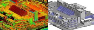
A point cloud shifts the paradigm from curated representation to recorded condition. By capturing millions of data points, interpretation is based on a full representation of reality rather than half truth of selected 2d Information. When a late-stage question arises“Can we fit a 300mm duct through this specific structural gap?” the answer exists in the point cloud data, even if the question wasn’t asked during the initial site visit. This provides the client with a form of “project insurance,” protecting the contingency fund from being drained by avoidable site discoveries.
2. Design is Already 3D; Our Inputs Should Be Too
There is a structural misalignment in many firms today. Structural engineers analyse load paths in 3D; MEP engineers resolve volumetric conflicts in 3D; architects coordinate spatial sequences in 3D. Yet, many of these projects still begin with ” a selective 2d guess ” as the input to design from.
This forces highly-paid professionals into compensatory labour: the tedious process of reconstructing 3D truth from 2D evidence. We “idealise” walls and “rationalise” grids not because the building is straight, but because the software demands it. Point cloud-derived models remove this geometric inference, allowing engineers to design against reality rather than a sanitised, “straightened” version of it.
3. Geometry as It Exists vs. Geometry as Assumed
In the world of existing buildings, “flat enough” is where the profit margin disappears. Whether it is a beam that has deflected 50mm over forty years or a column that isn’t perfectly plumb, these deviations are only “minor” until they meet high-tolerance prefabricated elements.
Point clouds make these conditions honest earlier, when honesty is in most cases more cost efficient to collect than traditional selective 2d traditional approach. For example by identifying non-planar soffits and construction drift during the design phase, misalignment ceases to be a site surprise and becomes a manageable design constraint. It allows for “clash detection against reality” rather than just clashing an 2.5D model against design.
4. How Risk Moves and Transforms
It is a common misconception that point clouds remove risk; in truth, they allow for it to be re-timed and moved to much earlier in the project lifecycle. Traditional 2.5D survey approaches defers risk downstream, where design decisions are locked in and corrective action is reputationally exposed. Comprehensive capture pulls that uncertainty/potential risk forward so it is seen before the design process commences. A much better place for risk to live
By adopting this approach, Design Risk is mitigated because assumptions about alignment and continuity are actually interrogated against as-built measured evidence. Coordination Risk specifically the invisible “tolerance stack-up” that plagues complex installs is resolved through spatial verification rather than interpretive drawing. Ultimately, this protects the Programme, as late-stage discoveries that force re-sequencing are eliminated. For the senior practitioner, this is not just about data abundance; it is about Risk Governance and establishing a defensible professional position.
5. Managing the Data, Not Just the Points
Most project managers and built environment professionals have learnt that “more data” does not always mean “better information.” One of the primary barriers to point cloud adoption has been “data bloat” the heavy, noisy files that can stall a workflow.
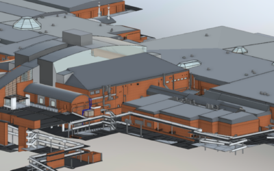
The professional necessity lies in the distinction between the Raw Point Cloud (the comprehensive record) and the Derived Model (the usable, lean tool). We don’t need to model every bolt to gain the benefits of reality capture; we need a model that accurately reflects the constraints that matter. Point clouds do not replace professional judgment; they discipline it by narrowing the gap between what is assumed and what is known.
6. A Change in Professional Posture-Being Able to Own the Unknown
The growing insistence on point clouds is driven by experienced engineers and architects who have learned, often expensively, where projects actually fail. To request comprehensive spatial capture is to assert that avoidable ignorance is no longer an acceptable part of the practice.
While the density of capture may vary from topographic mapping on a greenfield site to high-definition scans of a plant room the logic remains the same. As the industry moves toward tighter margins and more rigorous liability regimes, the standard of care is shifting. Beginning a complex project without a recorded reality is no longer a neutral choice; it is an active decision to understand and thus tolerate avoidable uncertainty.
Path forward
Point clouds have become the new normal because the old approach of 2D surveying does not reduce the risk profile of contemporary projects. We are moving from a world of “precise but incomplete” drawings to “comprehensive and actionable” data.
At our firm, we operate at the intersection of reality capture and professional decision-making. We help architects and engineers move from “measured conditions” to usable, defensible information, ensuring that judgment is exercised with the best available evidence.

0 Comments