First published in Imesa Magazine
Imagine Fortnite™ meets Minecraft™ meets the real-world city you live and work in – what a computer game that would be. Imagine working in a data rich 5D onscreen world that updates in real time and in which you can play “what if” scenarios. We’re there right now.
Take an accurate 3D representation of reality, be it your factory, sewage works, a portion of the CBD or an entire city. Now add to this the fourth dimension of how this world and its surrounding environment, such as weather, traffic, population growth and supporting services drive changes over time. Then layer behind this income, expenses and flow of money, as the fifth dimension, and you have yourself a digital twin.
The Internet of Things (IoT) allows data to stream between our physical world and computers, enabling us to live stream data from the urban environment. This is what’s moved our old fashioned 3D maps into live digital representations of the real world. This is how a digital twin becomes a dynamic ever-changing representation of reality, providing us with both reactive and predictive feedback.
For reactive feedback, as live traffic data streams in, we can adjust traffic flows to ensure better peak time use of the current roads in our city. Predictive feedback is when we use our digital twin to do future planning. Examples include simulations of population growth or cost increases or droughts to understand how best to allocate the finite resources available in the most sustainable manner.
You can look at a digital twin as a Wifi enabled Lego set. Are you considering a new taxi rank? Imagine putting together a Lego model of the planned rank. As you make changes you have a dashboard of data showing you how many people you can move through the rank, how peak time traffic flows around the rank will change and, critically, how your residents can save time moving through the rank.
Once the taxi rank is built you can add sensors such as traffic count, temperature, water and sewage flows and cameras. This allows your digital twin to suggest, in real-time, how to reactively use the resources in the rank most efficiently.
Modelling evolution
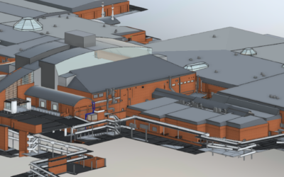
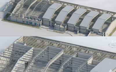
In the last century, the first digital 3D models of our environment began to emerge. Over the past 40 years or so, the 3D CAD model has grown into a building information model (BIM). The latter includes a 3D illustration of our building or environment, as well as embedded metadata about the components that make up the model. So, what are the tools needed to create a digital twin?
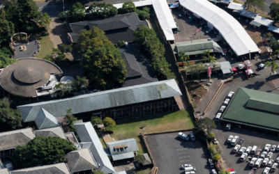
As a foundation you need accurate up to date geospatial data – the ‘Where’. The upside is that mapping has become super-efficient. By combining laser or lidar scanning with aeroplane or drone based aerial mapping, a 3D model of the built environment can be efficiently collected.
There are three main mapping tools to consider. Within the subsurface world, ground penetrating radar is the main one. Radar and electromagnetic pulses reveal the location of services such as electrical and communication cables.
Above ground, terrestrial laser scanning allows you to collect accurate street and ground level information such as roads, building footprint service access points, street furniture and terrain models.
For larger areas, traditional aerial mapping, using a combination of lidar (laser) and photogrammetric techniques, is the best way to build the 3D model upwards from ground level. Recent advances in cameras now allow the vertical view and the sides of buildings to be captured. This means the digital model can now accurately depict building facades and provides more understanding on how a building interacts with its outside world.
The ‘what’ and ‘why’
Drone mapping offers cost efficiency, simple data collection, and continual updates as the environment changes. Without a strong foundation of good continually updated 3D data, the trust in the predictive ability of the digital twin will be eroded.
The next step in the twin is the ‘What’. What is changing in the data flow? To understand this, a collection of sensors and data gathering tools are positioned in the real world. The digital twin is then updated with these sensor positions. Again, this highlights the importance of good 3D mapping. If the 3D model is poor, it will be hard to understand where the sensor data is coming from.
Sensors will measure parameters like weather information, pedestrian foot flows, traffic counts, services use, such as water, sewage and electricity, and internet data use, which are all fantastic for determining people density and rate of movement. This data can be combined with social media monitoring for feedback on how the cityscape is being used and user behaviour. Think nerves of the twin.
The third step is the “Why”. Why is the world changing? The resultant changes, shown in the sensor information, is the basis for informed decisions taken by the users of the digital twin model. This is where the changing relationship between people and the built environment is being modelled in real-time. A combination of machine learning and artificial intelligence allows the insights being collected by the geospatially positioned sensors to be converted into actions.
This is the last step in the data value chain that has been created by the building of a digital twin. Multiple data sources with position, time and cost information are now combined and synthesised into actionable data. Think brain of the twin.
“The influence of a digital twin is in its ability to help decision makers derive new insights and inform better decisions, providing a holistic visualisation of infrastructure asset information and performance,” says Robert Mankowski, Bentley Systems.
Benefits for municipal infrastructure
To appreciate the influence that digital twins can have on improving municipal management, consider the following possibilities:
Clear insights for improved infrastructure: a digital twin consolidates what municipal departments currently track separately – water pressure logs, road maintenance schedules, energy consumption patterns – into a single spatial model. When a district shows unusual water demand, engineers can immediately correlate it with population density shifts, new development approvals, and aging pipe infrastructure. Predictive algorithms can then flag which trunk mains will fail within 18 months, allowing planned replacement rather than emergency repair at three times the cost.
Make infrastructure last longer and be more resilient: by understanding how the built environment is being used and where the pressure points are, it is possible to plan for early maintenance that will allow the infrastructure to last longer. Rather than reacting to failures in infrastructure, the digital twin will model the cost of early maintenance and assist in the justification of an improved maintenance budget.
Public engagement: Residents typically see infrastructure decisions as fait accompli – the road closure notice arrives, work begins, complaints follow. Digital twins flip this sequence. A municipality considering three route options for a new BRT corridor can publish the models online, showing noise impact, traffic disruption during construction, and journey time savings for each option. Residents click through the scenarios, see how their street features in each, and comment with local knowledge engineers might miss for example that Service Road B floods every winter, rendering Option 2 unworkable. Public consultation becomes genuine dialogue rather than a box-ticking exercise.
Improved planning: Historic data from digital twins reveals patterns invisible in quarterly reports. Take stormwater management. Three years of rainfall data, combined with surface runoff measurements and underground pipe capacity, can model how a proposed 200-unit development will stress existing infrastructure during a 1-in-50-year storm event. Engineers can test various detention pond sizes, permeable paving options, and pipeline upgrades within the model with each scenario showing capital cost against flood risk reduction. The best solution emerges before a single excavator arrives on site.
Improved coordination: when roads and infrastructure departments operate in separate data silos, chaos follows. Roads schedules resurfacing work for Tuesday. Water discovers a trunk main leak Monday night and tears up the same street Wednesday. The newly laid tarmac gets excavated within 48 hours. With a digital twin, both teams see each other’s scheduled interventions, utility locations, and asset conditions simultaneously. A road engineer planning resurfacing spots that water mains beneath the route are 60 years old and nearing failure. One coordinated project replaces pipes and resurfaces together, halving disruption and cost. The street gets opened once, not twice.
Digital twins succeed because they dissolve the boundaries that fragment municipal decision-making. When surveyors, engineers, planners, and finance officers all work from the same spatial model – updated in real-time, historically consistent, financially transparent – infrastructure management shifts from reactive fire-fighting to strategic stewardship. As Sue Tabbitt observes in a recent Smart Cities report: “A state-of-the-art digital twin is essentially an integrated, centralised platform (or ‘nerve centre’), where diverse information about assets and associated services is combined, monitored, analysed and acted upon. It can be a critical facilitator of transformation – delivering benefits across all phases of the lifecycle of designing, running and maintaining/improving local infrastructure, whether within a single organisation or across an entire city.”
South African municipalities, already wrestling with crumbling infrastructure and shrinking budgets, can ill afford to ignore this shift.

0 Comments