5DGeo Remarkable Geospatial Insights
  • Home
  • Services
    • Aerial and Drone Mapping
    • Laser Scanning & REVIT Based 3D Models
    • Detailed Site Plans
    • Property Boundary Surveys, Subdivisions & Consolidations
    • Sectional Title Plans & Survey
    • Prospecting, Mineral & Mining Rights Plans
    • Engineering and Construction Surveying
    • Underground Services Detection
  • About
  • Contact
  • Blog
  • 082 773 4868
Select Page
Why investing 1% Upfront in Laser Scanning Pays Off  – What High-Fidelity point clouds and  Reality Models Actually Deliver.

Why investing 1% Upfront in Laser Scanning Pays Off – What High-Fidelity point clouds and Reality Models Actually Deliver.

by Chris Kirchhoff | Jan 21, 2026 | PointClouds

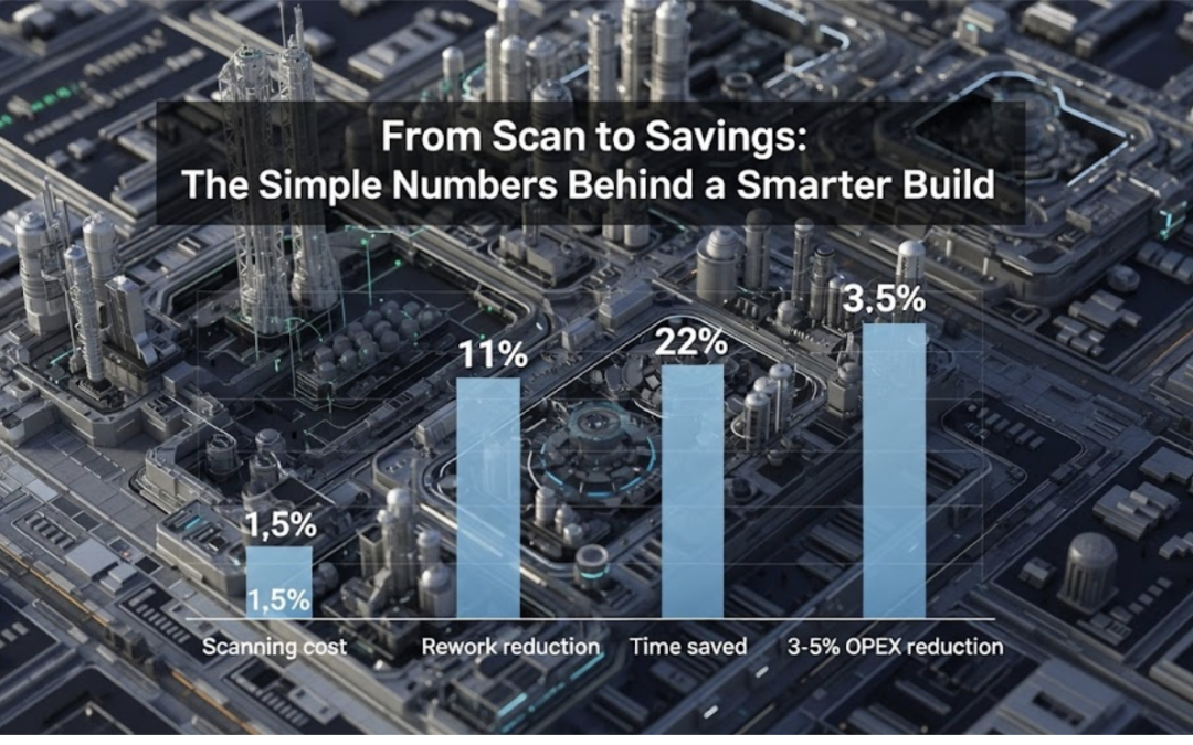
The question isn’t “why aren’t we investing 1% in 3d scanning ”—it’s “how much is rework costing you now?” Our clients use verified as-builts to drive speed, accuracy, and confidence across the entire project. It’s not the future of delivery—it’s already the...

Industry leaders in 3D Scanning, Revit modelling and Land surveying.

© 2023 5DGeo Pty Ltd.

PAGE LINKS

Home
Services

  • Aerial and Drone Mapping
  • Laser Scanning & REVIT Based 3D Models
  • Detailed Site Plans
  • Property Boundary Surveys, Subdivisions & Consolidations
  • Sectional Title Plans & Survey
  • Prospecting, Mineral & Mining Rights Plans
  • Engineering and Construction Surveying
  • Underground Services Detection

About
Contact
Blog

JOIN OUR NEWSLETTER
Sign up here and every 14 days receive - Industry best practice suggestions, Autodesk tips and learn about digital twins.

Success!

Subscribe

You can unsubscribe at any time. For more details, review our Privacy Policy.

Website by Stephen Strydom Digital Marketing.