
These experts provide accurate geospatial data that forms the bedrock of every development. Dive into the intricate world of land surveying and discover how these professionals are more than just measurers.
For those well-versed in the complexities of infrastructure projects, we understand that success lies in the details. One such detail, frequently underestimated, is the critical support role of Land Surveyors. Their work forms the bedrock of every project, yet their contribution is often overlooked in the project cycle. Below I am hoping to shed some light on the land surveying profession. We’ll explore the role of Land Surveying, the intrinsic value they add, and how their surveying expertise can be leveraged to drive project success, a world where precision, risk mitigation, and regulatory compliance intersect.
Infrastructure development is a multi-faceted and complex field that requires the integration of various disciplines, technologies, and expertise. One of the most critical, yet often overlooked contributors in this sector is the Land Surveyor, in particular how Land Surveyors are integral to infrastructure projects and how their work generates value and mitigates risks.
Pioneers of Precision
The foundation of any infrastructure project is accurate geospatial ( site plans ) information. Land Surveyors are the experts in acquiring and interpreting this data, providing an essential roadmap for the design, planning, and implementation of projects.
Highly precise geospatial data allows for accurate design and engineering of projects. It aids in the appropriate selection of the site, the design of the infrastructure to fit the topography, and even in the allocation of resources. This level of precision not only optimizes the design process but also significantly reduces the chances of costly reworks and adjustments down the line.
Risk Mitigation Maestros
Land Surveyors are the industry’s front-line risk mitigators. The geospatial data they collect and analyze can uncover potential issues long before they become problematic. Are there restrictive title deed conditions or municipal zoning issues ? Are there boundary encroachments, does the Topography lend itself to development, is the proposed construction site on a floodplain? Are there any underground utilities that could interfere with the project? Land Surveyors can answer these questions at feasibility study level, thereby preventing costly and potentially dangerous surprises later in the project cycle and critically pre-construction.
Additionally, accurate geospatial information is required for assessing the potential environmental impact of an infrastructure project. This enables developers to design and implement their projects in a way that minimizes environmental harm and aligns with sustainability goals.
Guardians of Compliance
Land Surveyors play a crucial role in ensuring cadastral ( boundaries) and town planning regulatory compliance. Local laws and Town Planning regulations dictate specific requirements for infrastructure projects, from boundary regulations to floor area ratios to environmental impact assessments. Land Surveyors’ expertise helps developers navigate this complex regulatory landscape, ensuring that projects comply with all necessary guidelines and avoid legal entanglements or delays.
In South Africa, Land Surveyors adhere to both the Land Survey Act 8 of 1997 and the supporting regulations , which regulates the survey of land and real rights in land and the Geomatics Profession Act 19 of 2013 which sets professional standards and controls who may practice as a Land or Engineering Surveyor. This adherence to regulations not only guarantees the quality and accuracy of their work but also enhances their credibility and reliability in the eyes of the project team.
Conduits of Sustainable Development
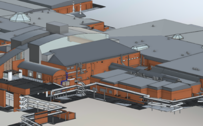
In today’s world, the importance of sustainable development cannot be overstated. Land Surveyors contribute significantly to this cause by collecting the geospatial data and then converting this into the information necessary to plan and implement environmentally friendly infrastructure projects. From identifying ecologically sensitive areas to assisting in providing plans and 3D Revit Models of existing structures in Brown fields developments, Land Surveyors help ensure that infrastructure development is sustainable and future-proof.
Land Surveyors are essential to infrastructure development, offering more than just measurements. They are experts in precision, risk mitigation, compliance, and sustainable development. Their knowledge and talents boost efficiency and safeguard against risks, making them indispensable for continued development.

3D Revit model of as built status for Brown fields development


0 Comments